Project overview
The project comprises three sections
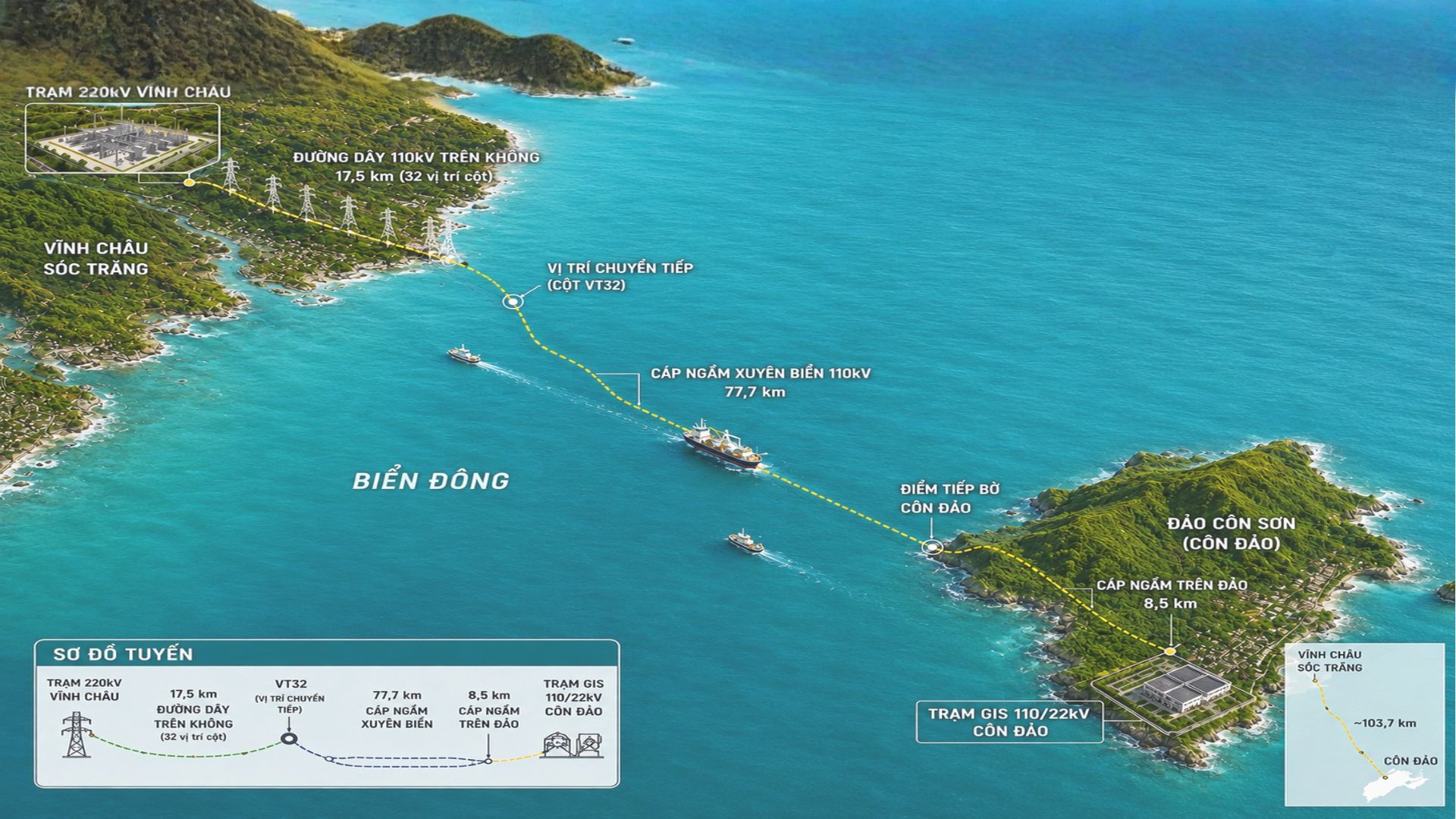
- Overhead line across tidal flats and the sea;
- Submarine cable;
- Underground cable on the island.
Key figures
- A 110 kV project with a total length of 103.7 km, comprising:
- 17.5 km of overhead line in the Vinh Chau area;
- 77.7 km of submarine cable linking the mainland to Con Dao;
- 8.5 km of underground cable on the island;
- A 110 kV bay extension at the 220 kV Vinh Chau Substation;
- Construction of the 110/22 kV Con Dao GIS Substation;
- Total investment of about VND 4,923 billion.
The hybrid overhead sea crossing, submarine cable and island underground cable route is the largest of its kind in Southeast Asia at the 110 kV level.
A power supply project combining an overhead transmission line with a submarine cable.
Source: VnExpress, 5 September 2025
Connecting Con Dao to the national grid is an energy project of special importance for socio-economic development, national defence and security, and Vietnam’s maritime sovereignty. The project was successfully energized in September 2025, officially connecting Con Dao to the national grid.
Challenges
01. A highly unusual hybrid route
The project combines an overhead line across tidal flats and the sea, a submarine cable, an underground cable on the island and a GIS substation. Each section has different natural conditions and survey requirements.
02. Complex terrain and access
Surveys along a sea corridor of nearly 80 km faced changing weather and ocean conditions: heavy rain, squalls, storms and tropical depressions, rough seas, high waves and complex currents. These limited working time and affected the stability of vessels and instruments, requiring careful planning, flexible survey operations and strict safety control.
03. Geology changing from mainland to island
Stratigraphy changed continuously between the mainland, tidal flats, nearshore areas, seabed and island. Surveys had to determine soft soil thickness, sediment characteristics, bearing capacity and adverse conditions for foundations and the cable route.
04. Foundations on tidal flats and at sea
Tower locations in flooded areas and at sea placed high demands on topographic, geological, tidal and bearing capacity data for deep foundation design.
05. Surveying the submarine cable corridor
The 77.7 km submarine cable required reliable data on seabed topography, stratigraphy, water depth and other factors affecting route selection, burial depth and cable protection.
06. Consistent data along the entire route
Survey data from the mainland, the sea and the island had to be linked in a single coordinate and elevation system and technical standard to support consistent design.
Resources deployed
People
PSC mobilized engineers, specialists and field teams from many disciplines:
- Surveying and mapping engineers;
- Engineering geologists;
- Marine geology and survey specialists;
- Hydrology and oceanography engineers;
- Drilling, sampling and in-situ testing staff;
- Laboratory testing and analysis engineers;
- Data processing, checking and management staff;
- Vessel operators and offshore survey support teams.
Teams worked simultaneously on the mainland, tidal flats, at sea and on the island, coordinated within a single management system to ensure quality and schedule.
Equipment
PSC deployed a complete set of equipment suited to each working environment:
- High-precision GNSS receivers;
- Total stations and levels;
- Measurement, positioning and route survey equipment;
- Onshore geological drilling rigs;
- Offshore investigation drilling equipment and systems;
- Floating craft for transport and offshore work;
- Seabed topographic and geophysical survey equipment;
- Soil, rock and sediment sampling equipment;
- In-situ and laboratory testing equipment;
- Systems for recording, storing and processing survey data.
Technology
PSC combined specialist survey methods with modern data collection and processing technology:
- High-precision satellite positioning;
- Seabed topography and stratigraphy surveys;
- Processing of geological, geophysical and oceanographic data;
- Integration of mainland, coastal, offshore and island data;
- Standardized coordinates, elevations and data structures along the entire route;
- Cross-checking and multi-level quality control.
Results and capabilities demonstrated
The project was successfully energized, bringing stable, continuous power from the national grid to Con Dao, reducing reliance on diesel generation, cutting emissions and laying the foundation for socio-economic development, tourism and services on the island.
The project demonstrates PSC’s ability to mobilize people, equipment and technology together to survey projects on any terrain and in any operating environment – from the mainland and tidal flats to the coast, the deep sea and islands.